
Big game migration
Game and Fish evaluates data and proactively manages migratory habitat throughout the state. Access the Governor's Migration Corridor Advisory Group mapping application, designated migration corridor information and the Ungulate Migration Corridor Strategy.
Migration corridors in Wyoming
Utilize the interactive mapping application at the link below to view migration corridors in Wyoming.
Migration Corridor Maps and Data
The following maps are for approved corridors and corridors under draft status. Draft maps may be subject to change.
Designated corridors
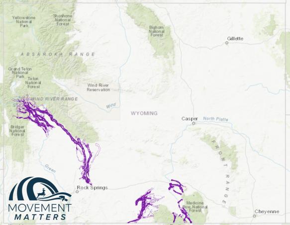
Sublette mule deer
The map is for approved corridors and corridors under draft status. Draft maps may be subject to change.
Platte Valley mule deer
The map is for approved corridors and corridors under draft status. Draft maps may be subject to change.
Baggs mule deer
Access geospatial data and the biological risk and opportunity assessment for the Baggs mule deer migration corridor. Draft maps may be subject to change.
Identified corridors
Sublette antelope
Access threat evaluation, maps and additional resources about the Sublette antelope corridor. Draft maps are subject to change.
Upper Wind River mule deer
Access threat evaluation, maps and additional resources about the Upper Wind River mule deer corridor. Draft maps are subject to change.

Geospatial Data
The following shapefiles provide geospatial data for the approved migration corridors as per the Wyoming Game and Fish Commission's Migration Corridor Policy.
Designated
Mule deer - Sublette
Mule deer - Platte Valley
Mule deer - Baggs
Identified

