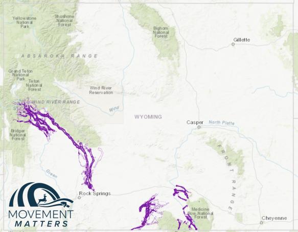
Sublette Antelope Migration Corridor
Wyoming is home to important mule deer and antelope migrations, including one of the longest antelope migrations in the continental United States. Each fall the Sublette antelope herd migrates south from summer ranges in the foothills of the Wyoming Range, Bondurant and Jackson Hole areas to lower elevation winter ranges near Pinedale, Green River and Rock Springs to escape the harsh winter conditions.
Wyoming is committed to conserving these vital movement areas, which help maintain populations by connecting seasonal ranges they depend on for sustainability. The Wyoming Game and Fish Department is following the public designation process outlined in the Migration Corridor Executive Order.
Overview and Next Steps
Threat Evaluation and Maps
Additional Resources
Geospatial Data
Risk Assessment
Public Comment

Migration corridors in Wyoming
Utilize the interactive mapping application at the link below to view migration corridors in Wyoming.
Frequently asked questions
-
Answer
Public engagement and commenting is essential throughout the designation process. There are at least six opportunities for the public to engage in the designation process:
- After the Department develops a Threat Evaluation with the initial footprint of the corridor
- During the Commission meeting consideration of this Threat Evaluation
- While the Department drafts the Biological Risk and Opportunity Assessment (BROA)
- During the Commission consideration of the final BROA
- When the Wyoming Game and Fish Commission decides if they will make a recommendation to designate the corridor to the Governor.
- The Governor’s Local Working Groups before and after designation also present numerous opportunities for public engagement.
This process is outlined in Appendix B of the Executive Order.
-
Answer
GPS collar data is evaluated throughout different parts of the corridor to assess the peak period of use each spring and fall. These periods are individual to each corridor and can be unique to different parts of each corridor due to the time required to move between winter and summer habitats, which can span several months. The peak period will not include all dates migration has occurred but is intended to capture the most critical time frame, realizing that annual climatic conditions can shift this window from year to year.
-
Answer
This has yet to be determined. Here's some information on the process and how it works: Game and Fish has created a Threat Evaluation report that is open for public comment and is currently engaging with landowners and stakeholders to gather input into the draft map and report. A final report is compiled after stakeholder and public outreach has been completed. The Department is slated to present to the Game and Fish Commission in March and provide a recommendation for either an identification or designation. During the meeting, the Game and Fish Commission hears additional public comment and then votes on whether to identify and/or recommend the designation of the corridor. The steps after this point are dependent on the vote above.
-
Answer
The data set used in this analysis goes back over two decades and includes data from 9 research projects on the various Sublette antelope herd segments. Migration corridors are based on years of collar data, public input and historic knowledge/data. The Department and various partners have deployed over 400 GPS collars on individual antelope in the Sublette herd from 2002-2022 and identified 806 migration ‘sequences’ (i.e., movement from winter range to summer range is one sequence).
-
Answer
The Brownian Bridge Movement Model (BBMM) method was used to designate the Sublette, Baggs and Platte Valley mule deer migration corridors. This method was also used to delineate stopover habitats in the Sublette antelope migration corridor. However, the Line Buffer Method was used in this analysis to identify the Sublette antelope migration corridor. In this method, lines connecting GPS points are buffered by a data-derived distance that envelops nearly all potential paths actually traveled by the animal between the points reducing the overall footprint of the corridor on the landscape. A distance of 300 meters was used to buffer line data due to the open landscapes and limited topographic relief to screen animals from disturbance. This distance is an appropriate space to maintain corridor functionality.
-
Answer
No, the direction provided in the Executive Order only applies to designated corridors. However, the Wyoming Game and Fish Department will continue to work with partners to implement conservation practices throughout the state, regardless of whether the area is within a designated or identified corridor.
-
Answer
No.
-
Answer
No, mineral development on private land is not restricted by the designation and Executive Order.
-
Answer
No, the State and the Wyoming Game and Fish Department will not be recommending changes to any grazing permits based on migration corridor function. All private land activities are outside the scope of the Executive Order.
-
Answer
Yes, existing permitted activities and activities associated with grazing are not subject to the terms of the designation and the Executive Order.
-
Answer
Hunting and outfitting are permitted or regulated activities, as we know it today, they do not jeopardize the functionality of the corridor and will continue to occur through the Wyoming Game and Fish Commission, the Wyoming State Board of Outfitters and Professional Guides regulatory frameworks.
-
Answer
No, existing recreational uses on public lands that do not require a special use permit are not limited by the designation and Executive Order. For events requiring a special use permit, the Wyoming Game and Fish Department may make comments based on the proposal’s potential impact on the migration corridor functionality.
-
Answer
No, new agricultural infrastructure such as fencing and water developments, including water pipelines, are not prohibited within designated migration corridors. The Wyoming Game and Fish Department can offer assistance and may look to make suggestions or help to find wildlife-friendly fencing options. These are voluntary programs that can improve migration.
