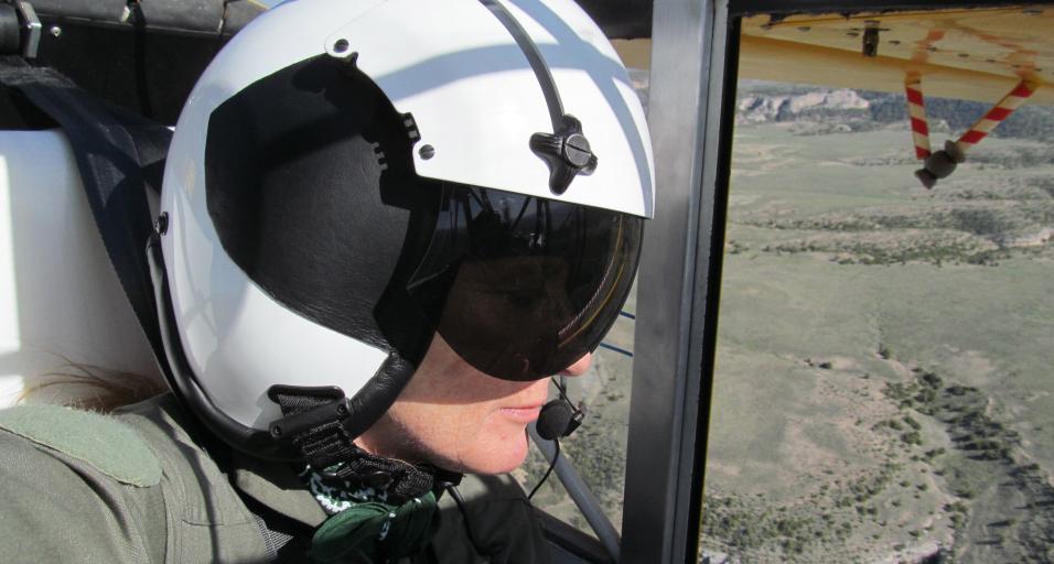
Imagine gliding high above the breathtaking landscapes of Wyoming, where the rugged mountains and open plains reveal a dynamic tapestry of life below. As you look down, you spot an animal. You carefully inspect to see if this is the species you’re looking for. As the dark figure moves toward the trees, you recognize it is a young Shiras moose, and you add it to your ongoing count.

A moose is spotted on the ground during an aerial survey in the Jackson Region. (Photo by Mark Gocke/WGFD)
Aerial wildlife surveys like this offer a unique view of habitats often unseen and difficult to access and provide the opportunity to see wildlife in a new and exciting way. But these high-flying adventures are just the beginning. As we descend back to earth, we'll uncover various survey methods that researchers use to study Wyoming’s diverse wildlife. Whether counting animals from the ground or air, listening for unique animal calls, collecting genetic information or obtaining essential data from hunters, each survey plays a crucial role in conserving the state's incredible wildlife.
WHO’S THERE AND HOW MANY?
The Wyoming Game and Fish Department often uses surveys to estimate how many individuals of a species are in a given area — also known as abundance. This knowledge is a cornerstone of population management.
Knowing the abundance of a species helps wildlife managers understand the density and status of a population, and abundance trends can signal to biologists if the ecosystem is staying healthy or is in decline. Over time, this information can indicate the effectiveness of conservation strategies and help inform management decisions.
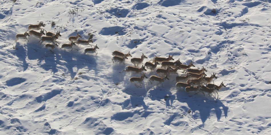
A herd of pronghorn runs through snow during an aerial survey. This type of survey may count the number of animals below or look at the ratio of male, female and juvenile animals. (Photo by Mark Gocke/WGFD)
There is no one survey type to determine population size. Wildlife managers consider things like animal behavior, habitat, terrain, land uses and more when determining which survey method will best estimate abundance.
Aerial surveys are one tool used to estimate population size, or abundance. These surveys involve using planes or helicopters to count animals or to determine the ratio of males to females and young animals. While it’s impossible to count every animal, biologists can use information from these aerial counts to estimate abundance.
Wildlife managers in Wyoming use aerial surveys to count various big game animals, including moose, elk, pronghorn, bighorn sheep and mule deer.
“A lot of our aerial surveys help in classifying animals,” said Corey Class, Game and Fish wildlife management coordinator in the Cody Region. “We can count to see what the buck-doe-fawn or bull-cow-calf ratios are in the area. These surveys also help us to understand population trends and can even show us how animals are using the land during certain times of the year.”
Aerial surveys aren’t limited to big game. For example, Game and Fish conducts aerial surveys of trumpeter swans, harlequin ducks, bald eagles and other raptors. Wildlife managers do this by checking known nest sites to see if they are occupied and surveying areas of habitat to count individuals. They also add additional nests they spot during the aerial surveys.
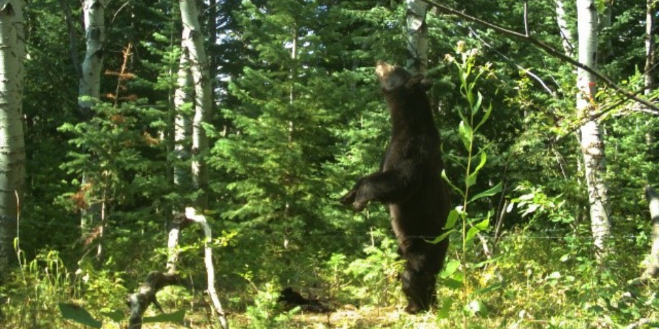
A black bear inspects a lure at a hair snare site in the Sierra Madres. (Photo by Ryan Kindermann/WGFD)
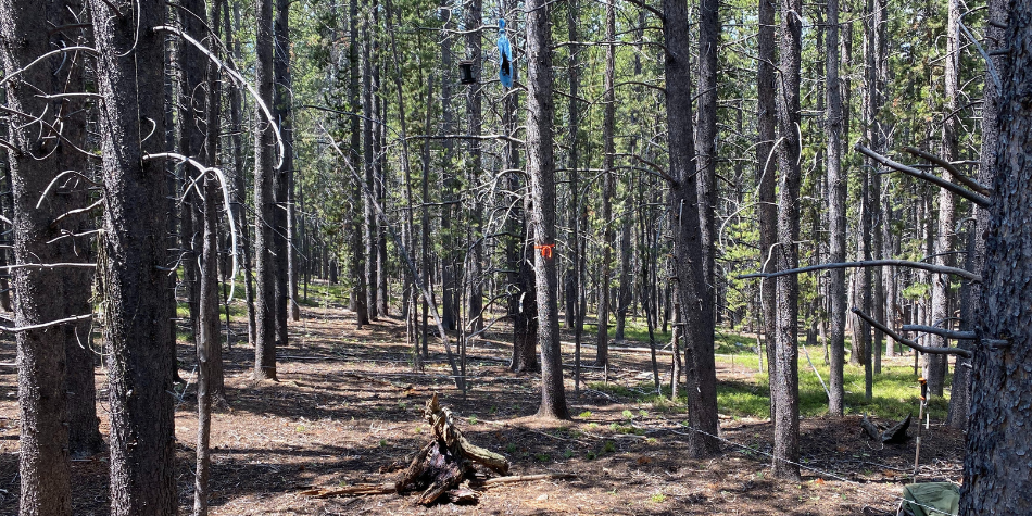
Wire snares around a scent lure are set up by wildlife biologists to collect black bear hair samples for the purpose of estimating populations in certain areas around the state. Wires are placed at a height where bears are forced to crawl under, resulting in some hair being left behind. (Photo by Ryan Kindermann/WGFD)
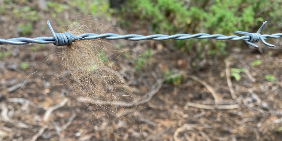
Black bear hair is caught on a hair snare set in the Bighorn Mountains. (Photo by Ryan Kindermann/WGFD)
Animals aren’t only counted from the air. Some wildlife is counted or classified from the ground. For example, Game and Fish employees attend sage-grouse leks — or breeding grounds — every year to count sage-grouse in attendance at the site. These counts give wildlife biologists an idea of sage-grouse population trends.
Another ground-led effort is the North American Breeding Bird Survey. This survey is conducted across much of the continent each spring, including in Wyoming.
“For the North American Breeding Bird Survey, dozens of volunteers and agency biologists drive established routes and stop at designated points to count all the birds they see and hear,” said Zach Wallace, Game and Fish nongame bird biologist. “We have data going back to 1966. No other multi-species bird monitoring program goes back that far. The volunteers for this program provide a great contribution to our understanding of the status of birds in Wyoming.”
As a complement to the breeding bird survey, the Integrated Monitoring in Bird Conservation Regions program, which is coordinated by the Bird Conservancy of the Rockies, involves technicians going to established areas and counting birds. This program has a rigorous protocol and sampling design to better estimate bird densities.
Wildlife managers aren’t the only ones contributing to population and abundance estimates. The public also plays a role in estimating this critical information. Every year, a random sampling of hunting license holders are asked to fill out a harvest survey. The survey gathers harvest information and feedback on the hunting season. Wildlife managers use hunters’ responses when making wildlife management decisions. These surveys allow Game and Fish to estimate harvest. For big game species, this is one of the variables that biologists use in population models to estimate herd abundance. Wildlife managers also use information from the harvest surveys when setting hunt quotas and season dates.
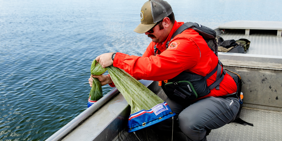
Travis Beam, Game and Fish aquatic invasive species specialist for the Laramie Region, collects a sample from a plankton tow at Wheatland No. 3 Reservoir. These surveys are conducted to detect for the possible presence of AIS in bodies of water across Wyoming. (Photo by Emalee Smith/WGFD)
It can be tricky to get population estimates for underwater species. In streams and rivers, fisheries managers utilize electrofishing to estimate fish populations. The process involves sending an electrical current into the water to stun fish. Game and Fish personnel net the fish as they float to the surface. This method can be useful to estimate fish abundance in streams and rivers, and it is a nonlethal way to sample fish.
In larger bodies of water like lakes, electrofishing is not as effective. Fish can navigate around and under the electrical current, so fish biologists often use nets to capture fish. Nets can be placed in the same locations over time, and fish managers can get a good idea of how the population is trending by comparing the species and how many fish are caught over the years.
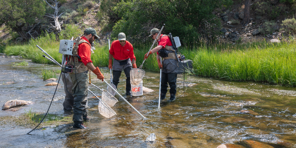
Personnel from the Game and Fish fisheries crew electrofish for hornyhead chub in the Laramie River near Wheatland. (Photo by Robert Gagliardi/WGFD)
Physically seeing an animal isn’t the only way wildlife managers can count wildlife. Some innovative techniques allow biologists to estimate a population without seeing the animals. For example, Game and Fish large carnivore biologists have implemented new strategies for estimating black bear densities by collecting hair samples from bears. This allows for estimating local densities and has been done in the Big Horn, Sierra Madre, Laramie and Wyoming Range mountains.
“Noninvasive hair snare sampling allows us to use the best available science informed by high-quality data when making management decisions for black bears,” said Ryan Kindermann, a Game and Fish large carnivore biologist who oversees black bear monitoring.
Game and Fish personnel place hair snares in bear habitat using scent lures to attract bears to the sites. The snares include a strand of wire stretched between trees at a height at which the bears must step over or crawl under, and a barb collects the hair for analysis. Wires are placed in a way to create a hair corral which bears must pass by if they are trying to inspect a scent lure. The lure does not provide a reward, but the scent attracts bears to the area. Genetic analysis of the hair samples determines the sex of each bear and how many individual bears came to the lure. Using models, biologists use that data to estimate the density of black bears in the area and couple this with harvest data to evaluate management objectives and population trends throughout the state.
Fish biologists also have found ways to survey fish populations without having fish in hand. Fisheries managers can use hydroacoustic monitoring to better estimate fish populations in large bodies of water. This method involves sending a hydroacoustic signal into the water, which bounces off objects in the water and returns the information to a display. It's similar to a fish finder commonly seen on boats but on a larger scale. This method allows biologists to estimate fish abundance in lakes without having to capture fish.
WHERE ARE THEY?
Not every survey is conducted to estimate the size or composition of a population. Some wildlife surveys are designed to determine if an animal is present. This could be to see if wildlife are using specific areas after a habitat improvement project or to monitor for threatened or endangered species.
Occurrence-based surveys are often used to determine if a potentially harmful species is present. A good example is monitoring for invasive species. Every year, Game and Fish technicians conduct plankton tows on waterbodies throughout Wyoming to monitor for invasives. These surveys involve collecting samples of water and organisms in a body of water and analyzing the samples for the presence of aquatic invasive species. Wyoming currently does not have any positive waters for harmful zebra and quagga mussels. These surveys help biologists to understand if these harmful mussels have been transported into the state and inform management decisions if they were to be detected.
While observations can be useful when determining if an animal is present, it’s not always the best way to detect occurrence. In some cases, animals are incredibly elusive and difficult to spot. The Great Plains toad is a good example. These amphibians spend most of their lives underground and only emerge for a short period of time to call, breed, feed and return underground. These toads are a Species of Greatest Conservation Need, and Game and Fish does not have many reported sightings. With these types of species, listening for them is the ideal solution. In 2019, the Game and Fish herpetology program organized multiple nighttime auditory surveys at locations in northeast Wyoming to listen for the toads. Through these efforts, Game and Fish personnel found toads present at many locations where they had previously been documented and found multiple new locations with the toads as well. However, he didn’t hear calls in some areas with recent development, and Game and Fish was concerned that activity may have affected populations. But because the toads don’t spend much of their life above ground, it was unclear if the toads had already retreated underground when Game and Fish was in the area or if the toads were truly gone.
In 2022 and 2023, more auditory surveys were conducted, this time adding the use of remote acoustic recording devices and newly developed call recognition models. Biologists could set out and program devices to record sounds multiple times a night over many weeks and use a computer to scan the recordings for toad calls. Through these efforts, Game and Fish found the toads were still present in those areas, and the missing toads from 2019 were due to timing rather than absence.
Fisheries biologists also use surveys to see if particular species are present.
“We do presence/absence surveys a lot in the fish world,” said Diana Miller, Game and Fish fish biologist in the Jackson Region.
“There are some streams that haven’t been sampled historically, so we may check them to see which species are there. We also can use this type of survey to see how a species’ range has changed or if a rare species is present.”
Aquatic habitat managers also may use presence/absence surveys to see if fish are using an area after a big habitat improvement project. In areas of the state where chemical treatments were conducted to remove a harmful species, biologists may check the water to ensure the treatment was successful. These surveys usually involve electrofishing or netting operations to check for the presence of fish.
Biologists also may check the water for environmental DNA — or eDNA. This method involves filtering the water for pieces of DNA left behind by the animals occupying the water. This can be particularly useful for rare or small-bodied fish that can evade capture through nets or electrofishing.
ARE THEY HERE?
Wildlife managers also conduct surveys to understand how wildlife are using the land. This may include understanding which habitats animals are using, how animals are moving across the land or when wildlife is in certain locations.
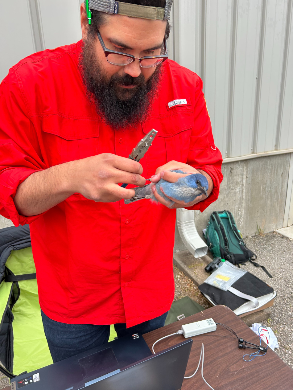
Frank Stetler, Game and Fish nongame biologist, applies a metal band to a pinyon jay before attaching a GPS transmitter to the bird. (Photo by Chloe Hernadez/WGFD)
One of the most common ways to understand how wildlife use the land is through GPS collaring. In this survey method, animals are captured and fit with collars containing a GPS. The collar monitors and pinpoints where that animal is at preprogrammed intervals and sends the data to a satellite for biologists to review or stores the data on the collar, which is then dropped after a certain amount of time and collected by wildlife managers.
In big game animals, this method often starts by netting animals from a helicopter, fitting them with a collar and releasing them. Knowing where animals are within the state, how they’re interacting with their environment and when and where they move helps wildlife managers understand migration routes, habitat needs and how weather is impacting populations.
“Those collars are worth their weight in gold when you consider they allow us to track an animal for a few years and understand their movements each season,” Class said. “That is very important for us as wildlife managers and gives even more information than an aerial survey, which only tells us where the animal is for a relatively short amount of time.”
Birds can be fitted with GPS transmitters to track their movements. For example, wildlife biologists have recently launched a program to place lightweight GPS units on pinyon jays in Wyoming.
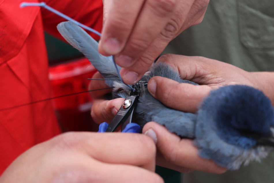
Biologists make the final adjustments to the first pinyon jay in Wyoming to be outfitted with a GPS transmitter. Biologists will use data from the device to analyze seasonal movements, land use and habitat selection of pinyon jays in the state. (Photo by Chloe Hernandez/WGFD)
“The classic pinyon pine-juniper woodland habitat of pinyon jays is very rare in Wyoming, but the birds can be found in other habitats across the state,” Wallace said.
“We’re working to learn more about where pinyon jays are nesting in Wyoming and how they’re using the habitats that are available to them here.”
Last spring and summer, bird biologists tested GPS transmitters on four pinyon jays to see how well they would work. They’ve already seen promising results and plan to place 30-40 transmitters on pinyon jays in 2025.
This method of marking and releasing animals works well underwater as well. Fish biologists often capture fish and insert them with a passive integrated transponder — or PIT tag. After the fish are released, the PIT tag can be picked up by antennae placed along the waterway. This technique has recently been used to learn more about fish migration in the Cowboy State and to monitor the effectiveness of projects meant to open connectivity for fish to navigate around barriers like dams.
It’s clear there that wildlife surveys are essential tools for wildlife and fisheries management. Whether through the air, underwater or firmly on the ground, these surveys help inform management decisions and assist in wildlife conservation throughout the state.
— Tracie Binkerd is the editor of Wyoming Wildlife magazine.

