The mapping tools available on the Wyoming Game and Fish Department website provide a couple great ways to explore Wyoming’s hunting and fishing areas. Using the interactive maps can also aid in preparing for your trip before your access area opens and can be a fun way to build anticipation leading up to your hunt.
Basic maps
If you just want a basic map to print or load to your GPS-enabled smartphone, every access area will have “print GeoPDF” or “print map” link for pre-made options. If you download it to your GPS-enabled smartphone, it has location data that will display your current location when used with a mapping app such as “Avenza Maps,” even when you’re without service.
Custom maps
When you want a custom map or other geographic tools, the interactive mapping applications on the website is where you can get creative for your needs.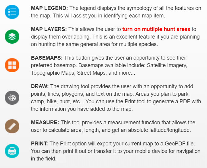
Checking the interactive maps, as well as the access charts or “ranch rule” documents, just before you leave for your hunt is a great way to ensure you have the most current information about the area.
Basic maps
If you just want a basic map to print or load to your GPS-enabled smartphone, every access area will have “print GeoPDF” or “print map” link for pre-made options. If you download it to your GPS-enabled smartphone, it has location data that will display your current location when used with a mapping app such as “Avenza Maps,” even when you’re without service.
Custom maps
When you want a custom map or other geographic tools, the interactive mapping applications on the website is where you can get creative for your needs.
- While most public access pages include an interactive map, you can ensure you have the most tools available by starting on the interactive map located on a webpage for a specific hunter management or walk-in area, or visiting the Hunt Planner.
- You can zoom in or out using your mouse (or two fingers on a smartphone) to specific locations.
- When you frame your map area, you can utilize a multitude of other tools using the icons along the bottom of the map. Each tool can be identified by hovering over it for a couple seconds: layers, basemap gallery, measurement, draw, legend, and print.
- You can add or remove layers from view, change the basemap to a different style using topography or satellite imagery, mark locations and draw directions and measure acreages or distance.
- When you have your ideal map, clicking on the “print” icon will allow you to choose the format and create a GeoPDF file to print or save to your portable device.
Checking the interactive maps, as well as the access charts or “ranch rule” documents, just before you leave for your hunt is a great way to ensure you have the most current information about the area.
Publish Date
Answered By
Jason Sherwood
Job Title
Laramie Regional Access Coordinator
Photo
Ask Game ID
209
Node order
95
Parent Node
1135